
Guides & videos
Getting started with Forest Assist
Forest Assist turns your iPhone into a forestry field notebook. It uses the phone's sensors — GPS, compass, camera, microphone, and LiDAR on Pro models — to record what you observe, where you observe it, and with no network.
This guide covers the first steps. Each module then has its own detailed guide.
1. Three things to know before heading into the forest
Everything works offline
None of your field actions needs a network. Your data is saved on your iPhone as you go. You can work a whole day deep inside a parcel without a single bar of coverage.
Nothing leaves your phone without you
Forest Assist collects nothing, does not track you and sends nothing over the Internet. Your positions, photographs and voice notes stay with you. The only data that leaves the phone is the data you export yourself, when you decide, to the destination you choose.
Everything belongs to a domain
A domain is a forest property or woodland. It is the binder in which everything is filed: your parcels, your paths, your observations, your usual species.
2. The home screen
At the top right, a GPS badge permanently shows your latitude, your longitude and the signal accuracy in metres. Three dashes mean the GPS is still searching: wait a few seconds in the open.
Seven tiles lead to the modules, plus Settings at the bottom:
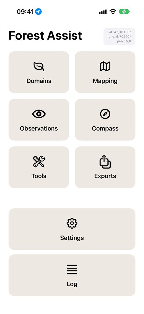
Each tile opens a module; the ↩ arrow always brings you back here.
| Tile | What it is for |
|---|---|
| Domains | Describe your properties and their contacts, place them on the map |
| Mapping | Survey your parcels and paths, by GPS or by hand |
| Observations | Photograph, dictate, inventory, measure basal area |
| Compass | Find a point you have already recorded, hold a bearing |
| Analysis | The statistical diagnostic of your plots: basal area, stem density, deadwood |
| Tools | Measure distance, diameter and height with LiDAR |
| Exports | Get your data out: mapping, spreadsheet, backup |
| Settings | Language, units, preferences, credits, hardware |
The detailed guide for each module is listed at the bottom of this page.
In every module, the ↩ arrow at the top right brings you back to this screen.
3. The "Domain" banner: your working context
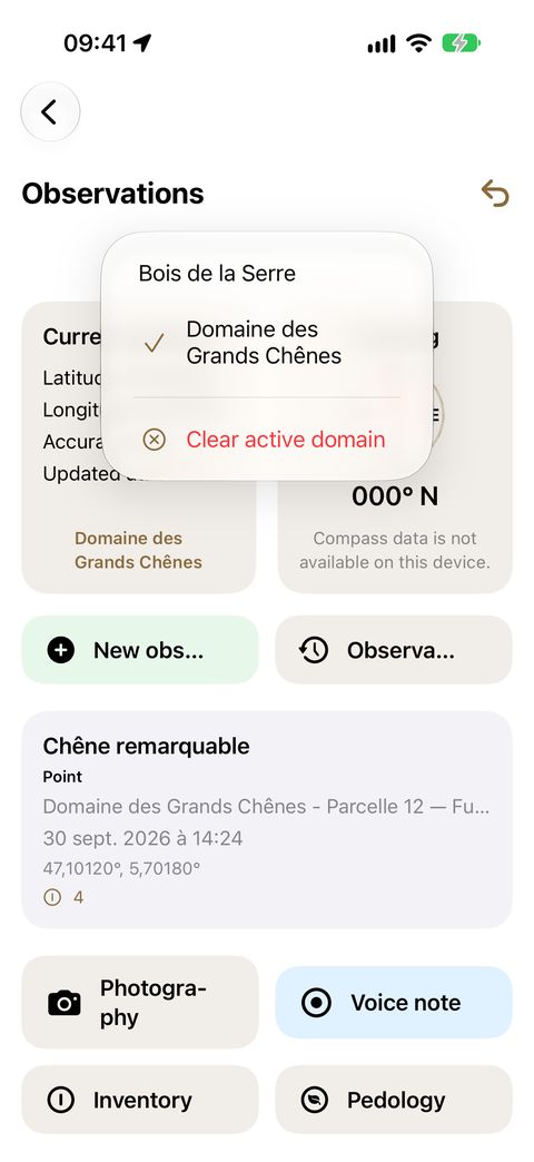
Below the title of most screens, a banner shows:
Domain: ⟨name⟩ ⌄
This is the active domain: the one you are working in right now. It determines what each screen shows you and where your entries are filed.
- Tap the banner to change domain.
- The Clear active domain entry resets it.
- Your choice is kept from one session to the next.
4. Your first half-day, step by step
- Create your domain. Name, city, postal code. Place the marker on the map — this is the point that will let the app recognise the domain when you are there.
- Set language and units in Settings if the values inherited from your iPhone do not suit you. Foresters often work in hectares and gradians.
- Draw at least one parcel in Mapping. This is the step that changes everything: as soon as a parcel is drawn, every observation made inside it is filed there automatically.
- Record an observation: go to the spot, tap New observation, then enrich it — Photography, Voice note, Inventory, Basal area…
- Export at the end of the day. At the very least, make a full backup and store it safely off the phone.
5. Automatic filing of your observations
This is the most useful mechanism in the app, and it works without you having to do anything. When you create an observation, Forest Assist looks for where to file it, in this order:
- Are you inside a drawn parcel? If so, the observation takes that parcel and its domain. If several parcels overlap, the smallest wins — the most precise one.
- If not, is a domain close enough? The app picks the nearest domain, within the limit of the Indexing precision set in Settings.
- If not, nothing. The observation stays unassigned. You can assign it later, by hand.
The observation's title is filled in automatically: parcel name (or domain name), date, time. You can replace it with your own.
6. Your credits
Forest Assist gives you 50 credits the first time you open it. One credit is used per recording action, and only for three of them:
| Action | Cost |
|---|---|
| Photography (or video) | 1 credit |
| Inventory | 1 credit |
| Basal area | 1 credit per survey |
| Creating an observation | free |
| Voice note and its transcription | free |
| Pedology | free |
| Viewing, correcting, exporting | free, always |
Your balance is shown in Settings ▸ General ▸ Number of observations, as remaining / total, with the breakdown by type of action just below.
Topping up: credits are bought on the forest-assist.fr website. You receive a code by email. Open Settings ▸ General ▸ Enter a credit code, paste it and tap Confirm. The message "Credit added." confirms the operation.
Three useful points:
- The check is done on your iPhone, with no network: you can top up in the forest.
- Credits add up and never expire.
- A code can be used only once ("Code already used.").
7. Permissions requested by the iPhone
The app asks for each permission at the moment it needs it, and explains why. None is used for any other purpose.
| Permission | Without it |
|---|---|
| Location | no geolocated entries, no track recording |
| Camera | no photography, no inventory, no sighting |
| Microphone | no voice notes |
| Speech recognition | voice notes recorded, but not transcribed |
| Photos | photographs cannot be saved or deleted |
| Motion | no heading, no inclination, no vertical sighting |
| Contacts | a domain's contacts entered by hand (instead of imported) |
You can review them at any time in the iPhone Settings app ▸ Forest Assist. The Settings ▸ Device Configuration ▸ Hardware Features screen tells you, capability by capability, what is active, inactive (to be authorised) or unavailable on your model.
8. Where is my data?
| Data | Where it lives |
|---|---|
| Domains, parcels, observations, inventories, notes | in the app, on your iPhone |
| Voice notes | in the app, on your iPhone |
| Photographs and videos | in your iOS photo library, album FA-⟨domain name⟩ |
An iCloud or iTunes backup of your iPhone includes the app and its data. For a copy you control, use Exports ▸ Export data (full backup) (Exports guide).
9. Frequently asked questions
Does the app work without a subscription? Yes. There is no subscription, no account, no sign-in. You buy credits when you need them, and they never expire.
Can I use it on several iPhones? Your credits follow you (they are linked to your Apple ID, not to the device). Your data, on the other hand, lives on the device: it does not sync from one iPhone to another.
What happens if I change iPhone? Restore your new device from your usual iOS backup: the app and its data come back. Your credit codes can be re-entered from the original email.
Is the GPS accurate enough under canopy? The accuracy shown in the badge tells you at all times. Under dense canopy, it degrades. For tracks, the app automatically discards outlier points and merges redundant points (Mapping guide).
In which languages? Ten: Dutch, English, French, German, Italian, Polish, Portuguese, Romanian, Spanish, Swedish. The app adopts your iPhone's language, and you can change it in Settings.